Vinicius M. Netto, Fabiano Ribeiro and Caio Cacholas
In a truly interdisciplinary work merging urban studies, statistical physics and computational science, we develop agent-based models (ABM) for simulating emerging behaviours in different urban environments. Our model analyses the degree of social entropy, an indicator of the degree of convergence between types of action as signs of social cooperation, in operation since our 1D model (Netto, Meirelles and Ribeiro, 2017). This step involves converging representations of physical and semantic environments as active information in the choice of activities and paths. These structures, in turn, are components that impact navigation and access, with repercussions on the fluidity of interactions and cooperation.
Our model Cooperation in Urban Environments (CUE) focuses on showing degrees of social cooperation in different spatial and semantic arrangements of cities. Following the example of our findings for physical environments (Netto et al., 2023), this resource allows the comparison of the performance of different urban areas and cities, via the inclusion of routines for analyzing access to opportunities in the agent-based model.
The development of CUE is based on a number of interdisciplinary fields:
- Information and entropy: conceptualization and measurements; analysis of spatial information;
- Cooperation in social and urban systems: emergence, modes, decision-making.
- Synchronization in complex systems: micro and macro dynamics, interaction patterns;
- Agent-based models (ABM) and simulation techniques;
- Spatial navigation in urban studies, neuroscience and cognitive studies;
- Virtual reality (VR) and virtual geographic environments (VGE);
- Validation techniques: empirical, statistical and computational techniques;
- Urban performance analysis: sustainability assessment and planning support systems (PSS).
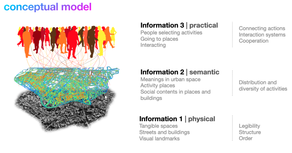
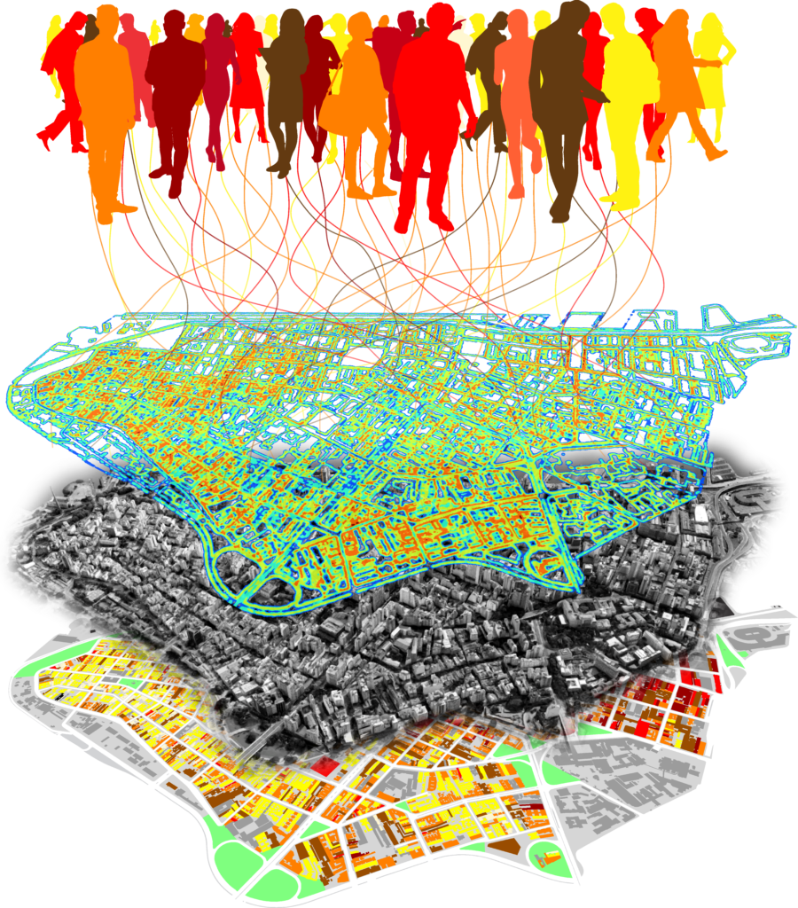
CUE integrates the representation of urban environments as systems of interactions between people and places, representing (i) physical information: urban structures (streets, blocks, buildings or lots), (ii) semantic information (types of activities in buildings) and (iii) agents (representing the behaviour of people in space).
- Agents and places have locality defined by coordinates in urban areas in a cellular grid.
- Agents have their own guidelines and carry out activities in the urban environment: they leave their original places and go to places with characteristics of interest to them at each iteration.
- Agents navigate the network of places based on options made by the user: from random walks to shorter paths based on non-Euclidean distances (i.e. calculated within the street network).
- Agents and places have mutable characteristics: they interact based on similarity parameters and influence each other according to ‘contamination’ parameters.
The model user parameterises the agents’ spatial and social behaviour:
- Degree of openness of agents to different places: the lower the parameter, the more conservative the agent is: it only goes to places similar or equal to its orientation.
- Agent’s spatial reach in relation to the availability of places: the higher the parameter, the greater the reach in the city.
- Degree of influence of places on the agent.
- Degree of influence of agents over places.
- Memory: the degree of influence of the agent’s previous actions on its next action.
The model allows exploring different sets of parameters and other parameterization possibilities.
- The model can use different representations of urban environments (e.g. maps of built form and land uses)
- Urban environments have active physical and semantic information: urban structures impact the choice of activities and navigation routes, with repercussions on the fluidity of interactions.
- Agents co-evolve with their urban environment.
- The model analyzes possible emerging patterns of synchronization of actions: it estimates the entropy in urban configurations, in the probability distributions of agents’ actions and types of activities in places, integrating semantic, visual and configurational aspects.
- This method allows estimating the impacts of different urban structures on how agents converge around types of action. For example, intricate urban structures may impact the ease of navigation, timing, and degrees of convergence of agents’ actions as a proxy for cooperation. The model will allow experimenting with hypotheses like this (figure 1).
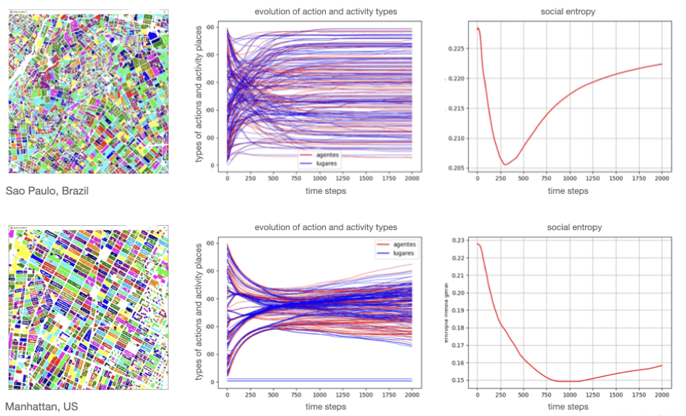
(Netto et al., unpublished simulations).
The model will include resources for visualizing the urban system during simulations: moving agents and changing their orientation and land use. The simulation will make it possible to see the urban system under analysis evolve over time, while the graphs will make it possible to understand what is happening in the way agents converge their orientations via entropy graphs, etc.
Graphical and mathematical outputs of the model to be developed:
- Spatial behaviour maps: paths and hotspots of movement and visit of agents. Emerging route patterns, with street hierarchy (partially developed — figure 4) for comparison with empirically captured routes and accessibility analyses.
- Model state maps (agent and place orientations) associated with timesteps.
- Routine for saving movies and clips (e.g. GIFs) from simulations.
- Histograms of the distribution of the number of agents along the field of possible orientations.
- Histograms of places visited by agents: list of agents that visit each place, number of visits to each place, ranking of most visited places, etc.
- Calculation of physical entropy (urban form), semantic (land use distributions), social (agents’ actions) and urban (agents and places) entropies during and at the end of the simulation.
- Entropy synthesis graph with results of different urban configurations for the same set of parameters and different sets of parameters for the same configuration (e.g. figure 2).
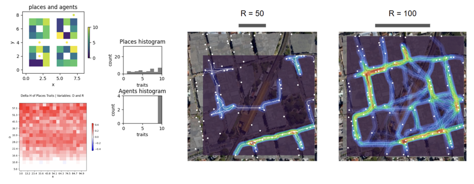
(Netto et al., unpublished simulations).
Construction of case studies in a Virtual Geographical Environment (VGE)
Development of visualization and virtual reality system for the reproduction of 2D and 3D urban environments, as well as interfaces for navigation in virtual reality (VR) and capture of individual spatial behaviours and collective patterns. It involves the following steps:
- Development of representation techniques;
- Elaboration of cases in a digital environment via the Unreal Engine platform, with a balance between temporal viability, scale realism, texture stylization and quality in the virtual experience. Development of user navigation application in online immersion;
- Inclusion of layers of environmental information: (i) the third dimension and differences between buildings as part of the problem of order and entropy, readability and navigability; (ii) landmarks and landmarks in readability (e.g. Stern and Portugali, 1999; Mülligan et al., 2011).
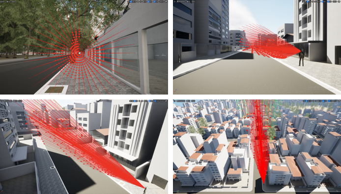
(author: Caio Cacholas; unpublished simulations).
* ABM CUE authors: Vinicius M. Netto (conception), Fabiano Ribeiro (conception, math), Iporã Possanti (algorithm, coding) and Caio Cacholas (technical support).
* Credit for conceptual images: Caio Cacholas (visualisation), Vinicius M. Netto (conception).
* Credit for ABM CUE images: Iporã Possanti.