
Is segregation encoded in urban form?
The footprints of residential segregation have long been documented, yet the role of urban form as both medium and manifestation of segregation remains under-specified. We investigate whether the configuration of the built fabric may encode residential segregation in its spatial structure, hypothesising that built-form entropy (BFE) regimes are associated with the spatial distribution of income groups and their local clustering in non-linear ways. We examine this by quantifying BFE through a Shannon-based measure computed from building footprints, characterising income-based distributions using the Gini index and Moran’s I, and placing both on a common spatial footing through a regular tessellation.
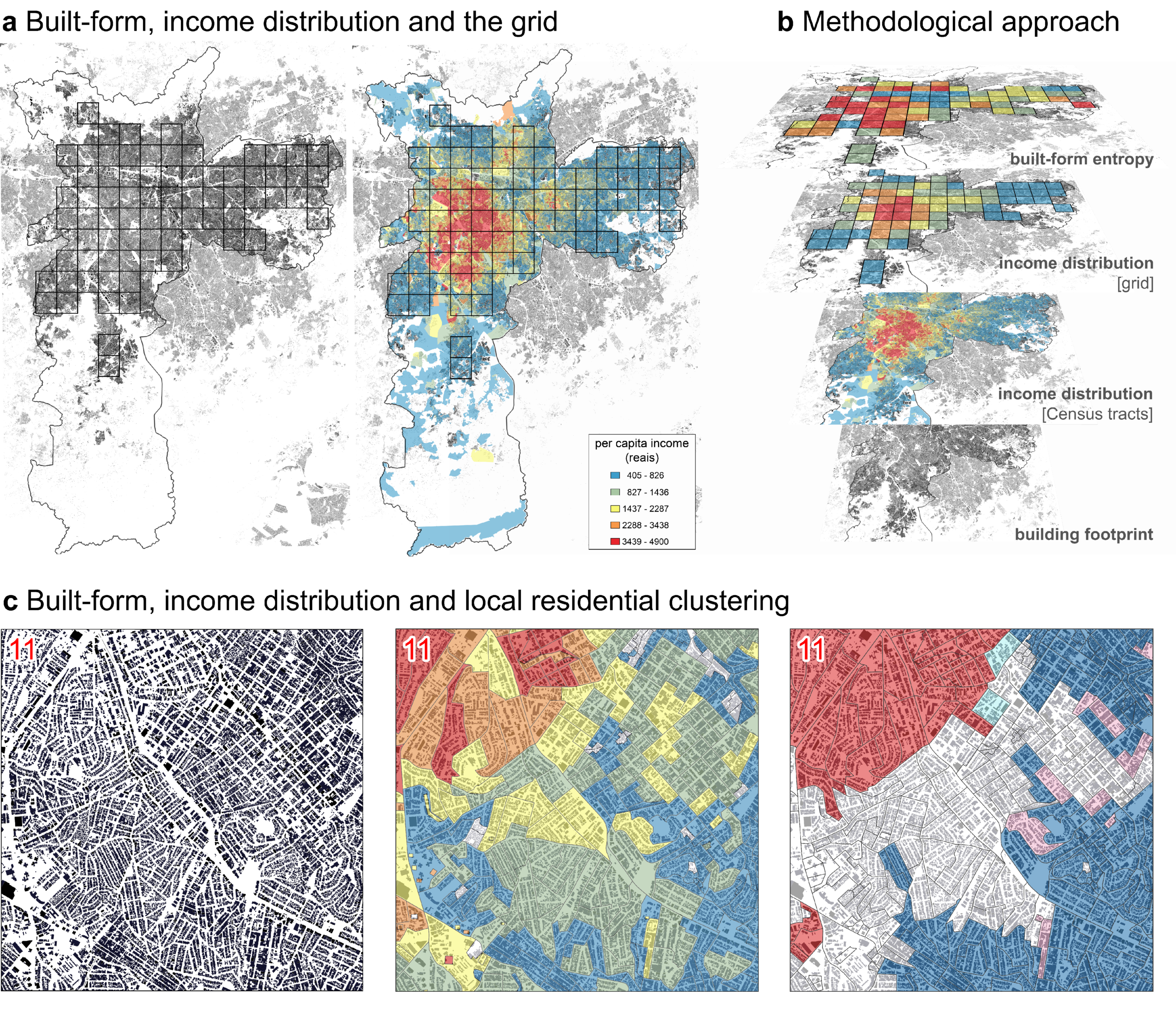
(a) Building footprints, tract-level average per-capita income and the regular 3×3 km grid. (b) Method schematic: overlapping the footprint and income layers to compute built-form entropy and residential-segregation metrics on the grid. (c) Grid-cell detail showing high built-form entropy, tract-level per-capita income, and Moran’s I (spatial autocorrelation). Sources: OpenStreetMap/GeoSampa (building footprint), IBGE (census tracts data), authors (analysis).
Applying this framework to São Paulo, Latin America’s largest city, we find non-linear relationships between BFE, income, and segregation: income levels and residential clustering increase toward both extremes of the entropy spectrum, with a stronger rise at the high-entropy end. This asymmetry suggests that high-entropy urban forms are associated with distinct spatial processes of segregation, including elite enclaving and incremental development in lower-income settlements, while low-entropy forms reflect more selective occupation shaped by planning and market filtering. Overall, the findings suggest that built form is more than a neutral backdrop, functioning as both affordance and signal of segregation.
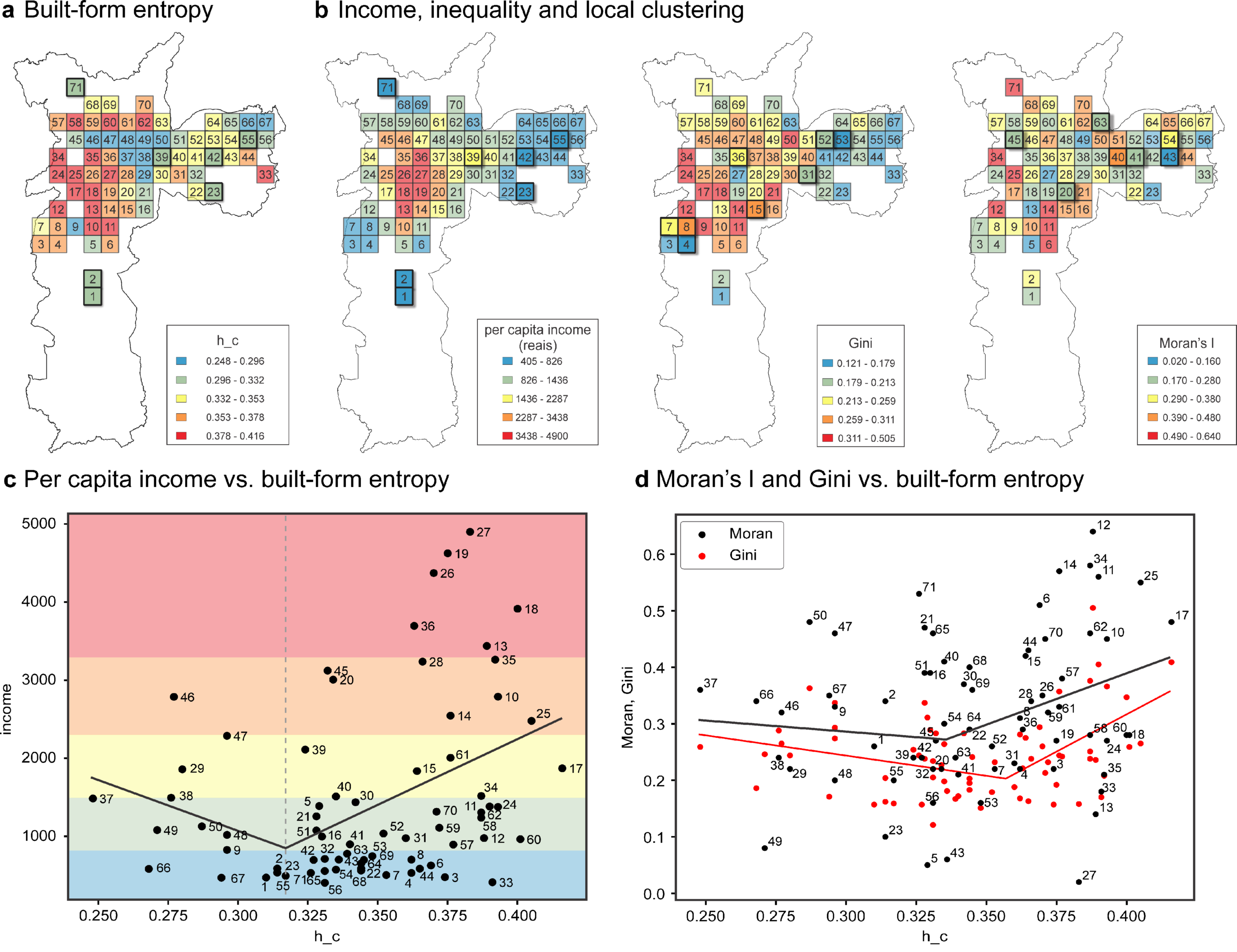
Built-form entropy, income distribution and local residential segregation in São Paulo. Top panels: (a) corrected built-form entropy (h_c) per grid cell; (b) average percapita income, income inequality (Gini) and residential segregation (Moran’s I) on the same grid. Cells outlined with thicker black lines in (a) and (b) mark areas whose values lie near the estimated threshold. (c) Scatterplot of per-capita income versus hc: the solid line shows the piecewise regression; the vertical dashed line identifies the estimated entropy threshold hTc ∼ 0.317. (d) h_c versus Moran’s I (black) and Gini (red); solid line, piecewise regression (Netto et al., 2026)
‘Segregation within segregation’: Residential segregation across scales
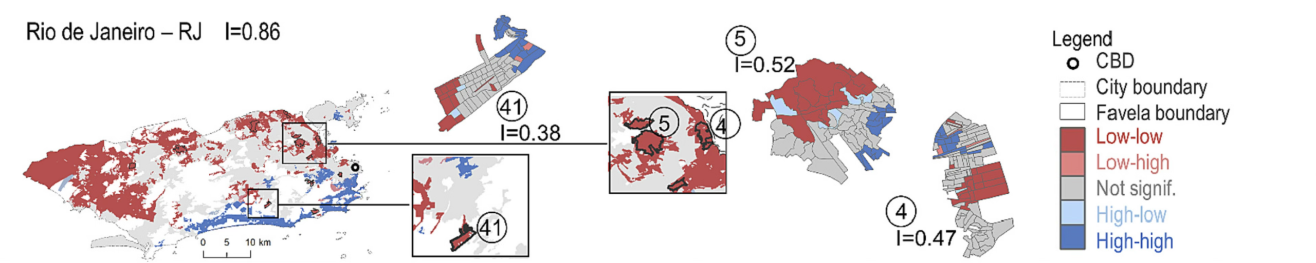
Residential segregation across scales in Rio de Janeiro: Moran’s I and LISA analysis of per capita income for the city and selected favelas, based on IBGE data (Carvalho & Netto, 2023).
This research examines residential segregation as a multiscalar phenomenon, focusing on how segregation can reproduce itself at very small scales within territories usually treated as socially homogeneous. Camila Carvalho challenges the conventional image of favelas as undifferentiated “pockets of poverty” by asking whether informal settlements contain their own internal patterns of separation by income, race, and access to infrastructure. Empirically, the research analyses large informal settlements across major Brazilian cities using census-tract data, spatial statistics such as Moran’s I and LISA, and clustering techniques. The findings show that many favelas are internally differentiated, with significant residential clustering by income and uneven access to urban infrastructure. Her work with Netto shows that segregation has a multiscalar, almost fractal character: it can appear not only between neighbourhoods or districts, but also within areas that are already segregated in relation to the wider city. This has important implications for how informal settlements are understood, represented, and targeted by urban policy.
Vertical residential segregation: the role of height and topography
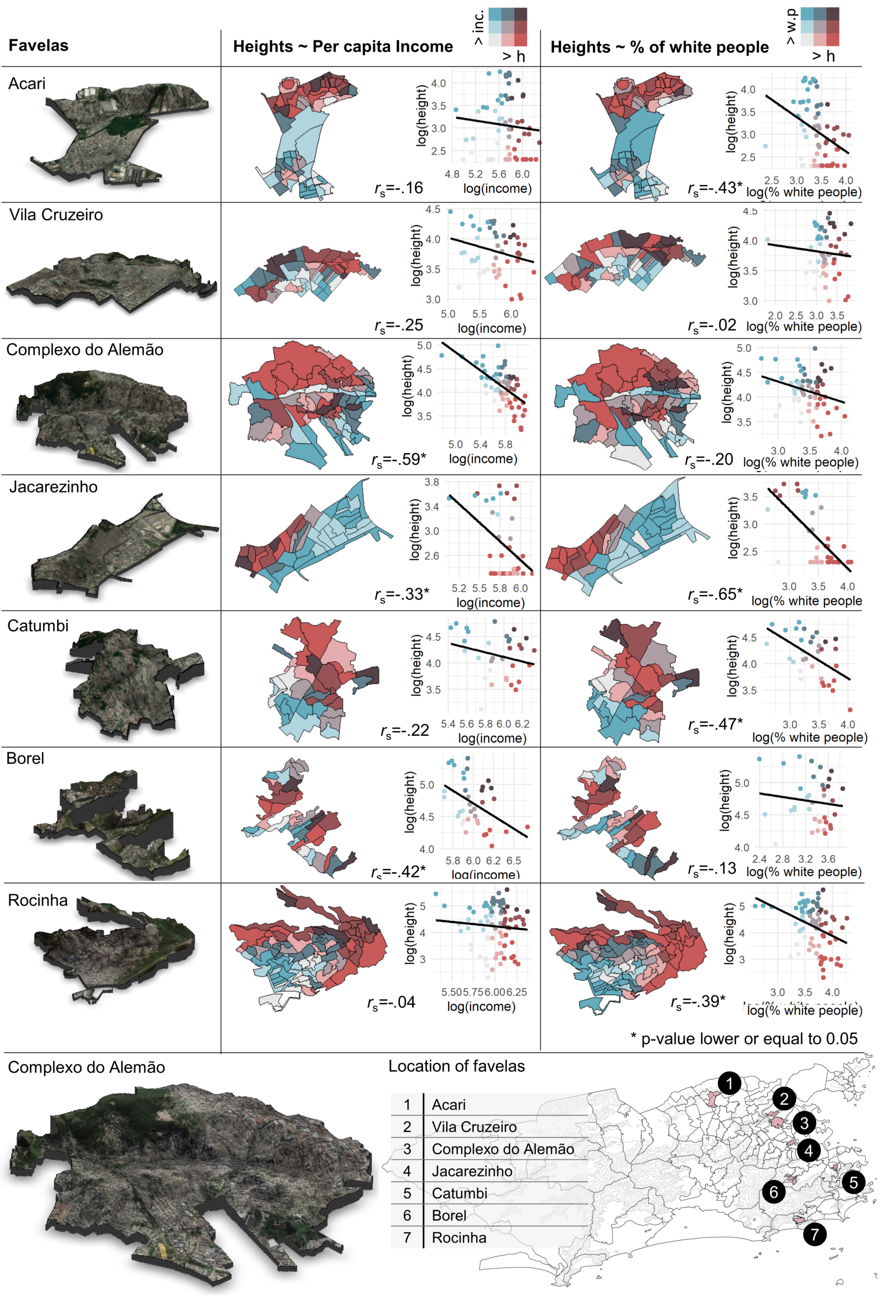
Vertical residential segregation by income (centre) and skin colour (right) in seven favelas in Rio, based on IBGE census data and Shuttle Radar Topography Mission elevation data from NASA (Netto et al., 2022).
Perceptions of segregation across scales
We examine residential micro-segregation across distinct dimensions: horizontal patterns between areas or neighbourhoods, perceptions of segregation at different scales, and vertical differentiation in both formal apartment buildings and informal hillside settlements. Survey results show that residents perceive segregation as strongest at the city scale, weaker at the district scale, and weakest at the building scale. Income and skin colour are seen as the main causes at larger scales, while political orientation becomes more relevant at the scale of buildings.
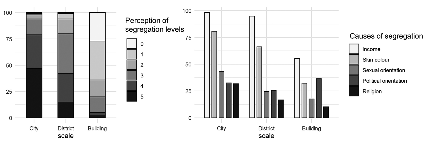
Perceived levels of segregation (left) and perceived causes of segregation (right) by spatial scale
(Netto et al., 2022).
The empirical analyses reveal contrasting vertical patterns. In formal apartment buildings, there is no strong general association between floor of residence and income, suggesting that vertical stratification is not a robust pattern in Rio’s formal housing stock. In hillside favelas, however, the pattern is clearer: poorer and black residents tend to live in higher, less accessible areas, while relatively better-off groups are more often located in lower areas, closer to infrastructure and access routes.
Conflict and territorial dynamics
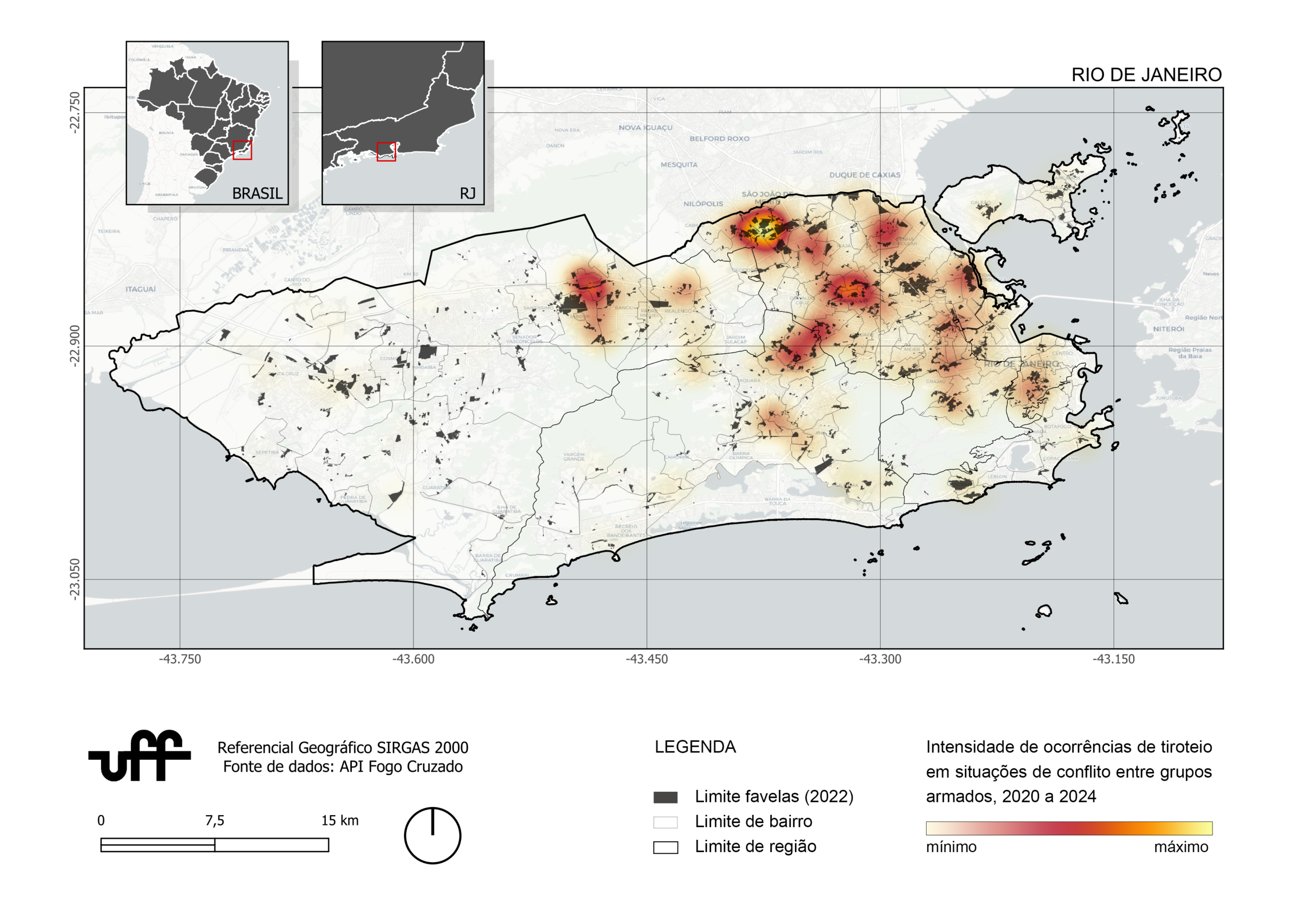
Heatmap and location of shooting occurrences in conflict situations between armed groups, police actions and operations in the city of Rio de Janeiro (2020 to 2024), based on data from the API of the Fogo Cruzado Institute (2025).
In this emerging research, Hiago Passos investigates armed conflict dynamics in segregated territories of Rio de Janeiro through a multidisciplinary approach combining computational modelling, game theory, and social-science concepts. The study examines how armed groups — including criminal factions, militias, and state forces — strategically interact in disputes for territorial control, expansion, and resources, producing complex patterns of violence, informal governance, and spatial reorganisation. Using agent-based models, the research simulates territorial expansion through individual and collective decision-making processes, incorporating variables such as force, cooperation, competition, and governance legitimacy. Beyond reproducing observed dynamics, it explores alternative scenarios and possible equilibria between actors. Ultimately, the work aims to advance methods for studying urban conflict while offering a critical understanding of the power relations shaping Rio’s contested territories.
Publications
Netto, V. M., Cacholas, C., Carvalho, C., & Brigatti, E. (2026). Is segregation encoded in urban form? An entropy-based analysis. arXiv preprint arXiv:2604.17643. https://doi.org/10.48550/arXiv.2604.17643
Carvalho, C., Netto, V.M. (2023) Segregation within segregation: Informal settlements beyond socially homogenous areas. Cities, v.134, p.104152. https://doi.org/10.1016/j.cities.2022.104152
Netto, V.M., Carvalho, C., Fiszon, M., Couto, Y. (2022) Micro-segregation in Rio de Janeiro. In: Vertical Cities: Micro-segregation, Social Mix and Urban Housing Markets. Cheltenham, UK: Elgar Publishing, pp. 154-171. https://www.e-elgar.com/shop/gbp/vertical-cities-9781800886384.html